Dr Samuel Hepner’s contributions to the SNSF Scientific Image Competition
A collection of photographs taken during various times of the SUSTAINFORESTS fieldwork.

Entry in category Object of study; Copyright CC-BY-NC-ND: Samuel Hepner
The photo shows a mona monkey (Cercopithecus mona) mid-air, jumping across a gap between a park and a forest patch in southern Nigeria. My research examines forest fragmentation—how large forests break into smaller patches—and how this opens forest structure, affecting habitats for monkeys and other wildlife. Fragmentation also affects people through the loss of ecosystem services like timber and carbon storage. I like this image because it captures a rare, risky moment: a tiny monkey making a huge jump, showing how life in fragmented forests is increasingly perilous. Taken with a simple smartphone, no special techniques—just timing and a fast finger.
Entry in category Video loop; Copyright CC-BY-NC-ND: Samuel Hepner
The video shows a rough, bumpy road, first from inside a car and then from outside, with researchers shaking as the vehicle moves. It ends in a remote African village, where the researchers exchange research results and share a film about forest sustainability with local people. My research focuses on understanding and sustaining forests in fragmented agricultural landscapes, where access is often difficult but local knowledge and engagement are essential. Reaching such places is challenging, yet crucial for science and society, as forests support biodiversity, livelihoods, and ecosystem services. I like this video because it captures both the physical effort of fieldwork and its purpose: connecting research with people. The journey is adventurous, but the reward is dialogue and shared learning. The video was taken with a GoPro 12 using a movement stabilizer; short clips are edited together.
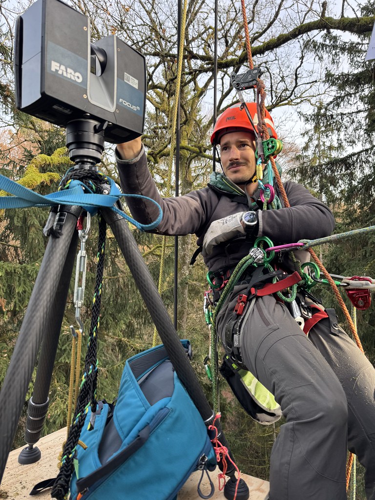
“Abseiling for science” by Vladimir Wingate, University of Bern
Entry in category Women and men of science; Copyright CC-BY-NC-ND: Vladimir Wingate
We are seeing Mr Hepner (before defending his PhD), 25 m up in the forest canopy in Bremgarten forest (Bern). He is initializing a Terrestrial Laser Scanner (TLS) which was mounted on a platform in the tree canopy with the help of Ms Tough (professional arborist) and Mr Wingate (Postdoc and author of the picture). Forests are rapidly changing under climate change hence it is necessary to monitor them. This project creates 3D virtual forest models to facilitate long-term monitoring of forests by harnessing remote sensing and arborist methods. I like this picture because it captures a motivated junior researcher going to great lengths to learn new methods and undertake daring field work, an industry professional sharing their depth of knowledge, and collaborative work to synthesis novel projects. Dr Hepner in the forest canopy initializing the TLS is the crystallization of these combined endeavours. This picture was taken with a smart phone spontaneously.
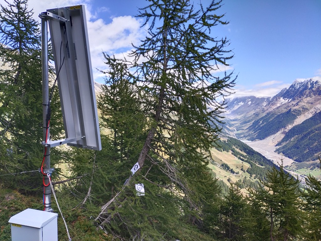
“Trees and landslides” by Samuel Hepner, University of Bern
Entry in category Locations and instruments; Copyright CC-BY-NC-ND: Samuel Hepner
The image shows a small solar panel and measuring device on the left, and trees marked with targets ready for monitoring with terrestrial laser scanning. The trees (Larix decidua), bent by winter snow, grow at the treeline high above the Lötschental. In the background on the right, the massive Blatten landslide, which completely buried the village, is visible. My research studies forests at their physiological limits, like treelines, which play a quiet but crucial role: while huge landslides like this destroy everything, smaller rockfalls and snow avalanches can be reduced by forests that stabilize slopes. With climate change, such hazards are expected to increase, while treeline forests must adapt to droughts and disturbances. I like this image because it captures two independent happenings that, in a broader sense, are connected. Taken with a simple smartphone, no special techniques.
The video shows a terrestrial laser scanner mounted on a temporary platform in a tree crown, followed by two arborists secured with ropes while working in the canopy. It ends with a rotating 3D point cloud of the tree, including a zoom into the crown structure. My research investigates a new approach to terrestrial laser scanning (TLS): lifting the scanner from the ground into the canopy to reduce occlusion and improve point cloud quality and density. This allows a more accurate representation of complex tree crowns. Such detailed structural data are essential for informed and sustainable forest management, which is increasingly challenging under climate change. I like this experience because it combines physical tree climbing with advanced technology. The video was recorded spontaneously on a smartphone, while the point cloud was captured with a FARO Focus M70 and visualized in CloudCompare.